For Emergencies Please Call 911


2005 Tornado
November 6th, 2005 McCutchanville was dispatched to assist Knight Township for a Tornado that had hit Eastbrook Trailer Park. The deadly tornado touched down about 25 miles southwest of Evansville Indiana, near the small community of Smith Mills KY in northwest Henderson county KY. The tornado rapidly became a violent F3 tornado and with a rapid rate of speed, it crossed the Ohio River three times before trekking across three southwest Indiana counties, leaving a 41 mile path of destruction and killing 25 people. This was the deadliest tornado to strike Indiana since 1974 and, at that time, it was the deadliest tornado since 1999 nationwide.
On the morning of November 5 2005, folks across the Tri State Region woke up a rather warm, humid morning with temperatures in the upper 50s to lower 60s along with a light southerly breeze. Thunderstorms were in the forecast for the day with the chances becoming more numerous through the night as a cold front was forecast to move eastward across the region. Severe weather was a possibility and at this point in the day, the thinking was that storms could produce some hail and damaging winds based on the strong winds throughout the atmosphere.
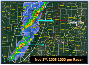
By late afternoon, temperatures had surged into the lower 70s with a strong south wind. In fact, the high in Evansville, IN on November 5 was 77 degrees, which was one degree shy of the record of 78, set back in 1975. By 600pm, a broken line of storms had formed in Missouri along the cold front. The threat for severe weather was increasing, with damaging winds and hail being the main threats expected, along with a few isolated tornadoes. The broken line of storms over Missouri was expected to congeal and strengthen into a fast moving squall line ahead of the cold front. This strong to severe line of storms would move into southern IL, western KY and southwest IN during the evening and into the overnight hours. Below is a radar image at around 6pm and a weather map at that same time, showing where the low pressure system and accompanying cold front were located
At around 900pm, the Storm Prediction Center highlighted the fact that this line was going to be moving into southeast MO, southern IL and west KY by late evening and by 930pm, a severe thunderstorm watch was issued for part of our area. By 956pm, our office began issuing warnings for parts of southeast MO as the line of potent storms began moving into our county warning area (CWA). An F2 tornado touched down in Ripley County Missouri at 1039pm and was on the ground for 7.4 miles. This tornado entered Ripley county from Oregon County. A home a barn received extensive damage in the community of Tucker, which is where the tornado reached its peak intensity and width. Peak winds were estimated near 120 mph with an average path width of 150 yards.
It would take until after 100am before the line of storms made their way across the Wabash River. The storms never really congealed into a solid line as expected. Instead, a broken line of embedded supercell storms were trekking east toward the Tri State Region. The NWS in Paducah was already closely watching a storm of concern over Union County IL just shortly after midnight.
The storm in Union County IL continued to move northeast across far southern IL and slowly strengthen. The circulation really became strong as it was crossing the Wabash River. By 132 am, a tornado warning was issued for parts of Henderson County KY and Posey County IN until 200 am:
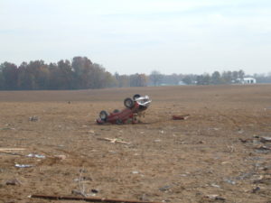
At 139 am, the tornado touched down in northwest Henderson County about 2 miles north northwest of Smith Mills KY and moved rapidly east-northeast across Ohio River bottomland. This fertile bottomland, used primarily for farming, was sparsely populated. Once the tornado began, it become violent very quickly and a well-defined swath of snapped and uprooted trees was visible by air. An isolated farm house a few miles northeast of Smith Mills was destroyed. A pickup truck at the house was thrown into a field and destroyed.
At 147 am, the NWS issued a tornado warning for southern Vanderburgh County, IN until 215am. About 5 minutes after that warning was issued, the NWS issued a statement that mentioned the city of Evansville was in the path of this tornado.
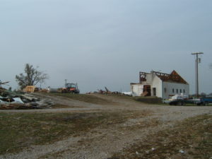
The tornado crossed into Vanderburgh County, Indiana from Henderson County, KY at a peninsula formed by the Ohio River just west of Henderson, KY. This peninsula is Ohio River bottomland primarily used for farming. From the air, scour marks were clearly visible on farmland. There were very few structures impacted in this small part of the county. A two-story house built in 1875, sustained major roof damage. Tree branches were embedded into the house. One farm equipment shed was demolished and another sustained major damage. A 10,000-pound truck was flipped over. Heavy farm equipment was moved several feet.
The tornado crossed the Ohio River for a second time and moved back into Henderson County, KY at 150 am. Henderson County KY was still under the tornado warning that was initially issued at 132 am. This part of Henderson county is a sparsely populated flood plain, used mostly for farming. The tornado then crossed the river a third time less than a mile west of the U.S. Highway 41 twin bridges. The river does not form the state line at the third crossing. From the bridges, extensive tree damage was visible along both sides of the Ohio River. Almost immediately after crossing the river, the tornado slammed into a horse racing facility named Ellis Park. There was extensive damage to grandstands and housing facilities for jockeys. A few race horses were killed. This facility was the first major facility to be impacted by the tornado. The tornado then crossed back into Vanderburgh County, Indiana after striking Ellis Park.

At 154 am, the tornado crossed back in Vanderburgh County IN. The tornado moved rapidly east-northeast at close to 60 MPH, staying a mile or less south of Interstate 164 and the southern city limit of Evansville. Shortly after 200 am, the tornado moved directly over Eastbrook mobile home park, which is on the south side of the interstate. Twenty people perished at this mobile home park. Of about 350 mobile homes in the park, 100 were completely destroyed and another 125 were damaged. Several of the fatally injured persons were found in a nearby retention pond that was drained to find victims. An 8-year-old child was found alive in a ditch after being trapped under debris for about 12 hours. One person died of complications from tornado injuries on December 17, 2005.

A tornado warning was issued by the NWS for Warrick County IN at 159 am. At 203 am, the tornado exited Vanderburgh County IN and crossed in Warrick County IN. Due to the extreme rate of speed, the tornado crossed the entire county in less than 20 minutes. The tornado reached its peak intensity in Warrick County, where winds reached about 200 MPH. The peak winds occurred along Highway 261 and Lincoln Road, in an industrial park near Paradise, and in DeGonia Springs. As the tornado passed south of Boonville, the county seat of Warrick County, a teenage girl was killed in a vehicle. In the community of DeGonia Springs, three persons in a mobile home were killed. One of the victims was a woman who was 8-months pregnant. From the north side of Newburgh to DeGonia Springs, houses were severely damaged or destroyed and vehicles were tossed. The tornado passed just to the south of Tennyson before exiting into Spencer County.

At 211 am, the last tornado warning for this tornado was issued for Spencer County IN. The tornado passed just to the south of Tennyson before exiting into Spencer County. The tornado crossed into Spencer County from Warrick County at 222 am just before dissipating. Some tin and insulation was found in a field at the end of the tornado track. The tornado was estimated to have weakened to F0 strength shortly before it entered Spencer County.
